Kautiliya Nagara Vyavastha (कौटिलीयनगरव्यवस्था)
Kautiliya Nagara Vyavastha (Samskrit: कौटिलीयनगरव्यवस्था) refers to the principles of town planning as reflected in the text of Arthashastra (अर्थशास्त्रम्) by Kautilya (कौटिल्यः).
परिचयः ॥ Introduction
As urbanization and globalization continue apace, cities will become the front line actors in the carbon emissions and climate change arenas. Recycling practices are among the most promising at reducing the ecological footprint of cities and entire city regions.
The future of hundreds of millions of people in urban areas across the world will be affected by the different impacts of rapid urbanization and climate change. The impacts will vary depending on the form of settlement, geographic considerations and the nature of the local economy. The overall vulnerability of human settlements will increase as confirmed by various scenarios which project that further global warming over the next decades is inevitable.
The Vedic traditions are known to have the aspects of sustainability and being eco-friendly in the core of their practices.
Kautilya’s Arthashastra is considered to be a comprehensive treatise and addresses those entire essential fundamentals specific to the practices of design and development of human settlements. He defines a hierarchy of urban centers and their administrative divisions. So as to ensure a bare minimum quality of life, he recommends different sizes of towns based on the available natural resources and also defines limits to their expansions.
क्षेत्रविनियोगः ॥ Land Use
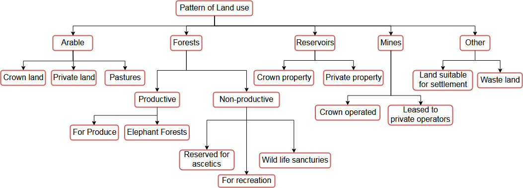
Kautilya recommended different types of land uses viz. Cart shed, Storage shed, threshing floor, vegetable garden, irrigated land, dry cultivation, pasture (3.9.25).[1]
विवीत-स्थल-केदार-षण्ड-खल-वेश्म-वाहन-कोष्ठानां पूर्वं-पूर्वं आबाधं सहेत ।। ०३.९.२५ ।।[2]
vivīta-sthala-kedāra-ṣaṇḍa-khala-veśma-vāhana-koṣṭhānāṁ pūrvaṁ-pūrvaṁ ābādhaṁ saheta ।। 03.9.25 ।।
The chancellor was expected to keep precise and detailed records of land use and anticipated revenue, helped by magistrates and secret agents.[1]
समाहर्तृवन्नागरिको नगरं चिन्तयेत् ।। ०२.३६.०१ ।। दश-कुलीं गोपो विंशति-कुलीं चत्वारिंशत्-कुलीं वा ।। ०२.३६.०२ ।।
स तस्यां स्त्री-पुरुषाणां जाति-गोत्र-नाम-कर्मभिः जङ्घ-अग्रं आय-व्ययौ च विद्यात् ।। ०२.३६.०३ ।। एवं दुर्ग-चतुर्-भागं स्थानिकश्चिन्तयेत् ।। ०२.३६.०४ ।।[3]
samāhartr̥vannāgariko nagaraṁ cintayet ।। 02.36.01 ।। daśa-kulīṁ gopo viṁśati-kulīṁ catvāriṁśat-kulīṁ vā ।। 02.36.02 ।।
sa tasyāṁ strī-puruṣāṇāṁ jāti-gotra-nāma-karmabhiḥ jaṅgha-agraṁ āya-vyayau ca vidyāt ।। 02.36.03 ।। evaṁ durga-catur-bhāgaṁ sthānikaścintayet ।। 02.36.04 ।।
Meaning: Like the Collector-general, the Officer in charge of the Capital City (Nagaraka) shall look to the affairs of the capital. A Gopa shall keep the accounts of ten households, twenty households, or forty households. He shall not only know the caste, gotra, the name, and occupation of both men and women in those households, but also ascertain their income and expenditure. Likewise, the officer known as Sthanika shall attend to the accounts of the four quarters of the capital (Arth. 2.36.1-4).[4]
The Pattern of land use as per Kautilya may be explained as follows:

Some interesting points raised by the Arthasastra include:
- The town should be not have surplus population which should then be housed in a new place.
- Towns should be positioned to help each other.
- ‘Sangrahan’ (collection register / tax collector) – 10 villages, ‘sarvatik’ among 200 villages, ‘dronamukh’ (chief) among 400 villages and ‘sthaniya’ among 800 villages.
- Migrated people in new settlement exempted from payment of taxes for some years
- A city should be located centrally to facilitate trade and commerce.
- The site should be large in area and near a perennial water body.
- The city shape should be circular, rectangular or square as per the topography.
- There should be separate areas for marketing different goods.
- The wall around the town should be 6 dandas high and 12 dandas wide. Beyond this wall there should be three moats of 14 feet, 12 feet and 10 feet wide to be constructed four arm-lengths apart
- Three east-west and three north-south roads should divide the town.
- The main roads should be 8 dandas wide and other roads 4 dandas wide.
- There should be 1 well per 10 houses.
Today’s Challenges
Climate change brings new challenges, which impact the natural and built environments and aggravates existing environmental, social and economic problems. Clearly these changes will affect different aspects of spatial planning and the built environment, including external building fabric, structural integrity, internal environments, service infrastructure, open spaces, human comfort and the way people use indoor and outdoor space. Coupled with the challenges of rapid urbanization, climate change impacts will undermine country efforts to achieve the goals of sustainable development.
Nowadays, as a result of technological advancements, integration of societies and economies of the world, planning of cities and regions has become very complex. Professionally trained planners are therefore needed in order to evolve new options for the development and management of human settlements. This applies not only to the planning of metropolitan areas but also to small cities, towns and villages. Drawing from the sophisticated and planet friendly paradigms of ancient India will greatly benefit the planners and policy makers of today.
References
- ↑ 1.0 1.1 L.N.Rangarajan (1992), Kautilya The Arthashastra, Penguin Books.
- ↑ Kautilya, Arthashastra, Adhikarana 3, Adhyaya 9.
- ↑ Kautilya, Arthashastra, Adhikarana 2, Adhyaya 36.
- ↑ R. Shamasastry, Kautilya's Arthashastra.
- ↑ L.N.Rangarajan (1992), Kautilya The Arthashastra, Penguin Books.